
Little Falls Historical Society Museum
  • HOME
  • BECOME A MEMBER
  • WRITING SERIES
  • CONTACT US
  • NEWS
    • Mat Rapacz Archives
  • EXHIBITS
    • CURRENT EXHIBITS
    • VIRTUAL EXHIBITS
    • ONGOING EXHIBITS
  • EXPERIENCE LITTLE FALLS HISTORY & HISTORIC ENTRY
    • Audio Tours
    • Echoes of Legacy
    • Historic Homes and Places in Little Falls
  • BOOKS AVAILABLE
  • SUNY ONEONTA’S COOPERSTOWN Graduate Program | Museum Studies
  • HISTORY SUPER SLEUTH
  • FOR THE HISTORIAN
    • Pre-human History – 1500
    • 1490 – 1650
    • 1651 – 1790
    • 1791 – 1870
    • MAKING HISTORY TODAY
      • Student Edition
  • ABOUT US
    • ANNUAL REPORTS
    • Privacy Policy
  • OUR SPONSORS
  • Menu Menu
  • Link to Facebook
  • Link to Instagram
  • Link to Mail

Little Falls, NY

  • This day in history: August 12

    1847

    The new Benton House has opened (later Girvan House) to the public under the directorship of Mr. Giles Orcutt of Binghamton. It is pleasantly situated at the corner of Main and Ann streets, a short distance from the Rail Road Depot and the Packet boat landing.

    1870

    A man named Donaldson walked a tight rope suspended across from the Petrie building to the Loomis building, in a bag and blindfolded.

    1884

    Work on the Little Falls Roller Skating Rink at the corner of Main and John streets is to be commenced this week at a cost of $4,000. The skating floor will be 49 by 128 feet – all appointments to be first class.

    1886

    The last shipment of starch was made from the Gilbert’s factory ending many years as the village’s leading industry. The raw material had been unloaded to the large storage building on the Erie Canal and conveyorized across Seeley Island to the factory on the Mohawk River for processing. The building will be converted to a knitting mill under the direction of J. J. Gilbert.

    1895

    Manager Tittle of Camp Jolly launched the new barge “City of Little Falls” to be used to transport up to 500 passengers to the campgrounds a few miles east of the city. The double-decker is 55 feet long and 14 feet wide and will be lashed to the “Victor Adams” which can accommodate an additional 200 people. There is room on the barge for dancing.

    1922

    “Kite Day” will be introduced to hundreds of Little Falls kiddies, under the age of 12, when they have the opportunity to make a kite and flying it the highest altitude in a contest under the auspices of the Y.M.C.A.

    1930

    Dan Vickers (later Dr. Dan Vickers), son of Dr. and Mrs. H. W. Vickers, and Wells Davy, both of Little Falls, made their first solo flights at Seymour field near Little Falls. They are members of the Little Falls Flying Club where nine other members are learning to fly.

    1967

    The Eastern Herkimer County Industries Inc. has purchased 24 ½  acres of land from the New York Central Railroad Company. This land, between the railroad tracks and the Mohawk River, comprises the Riverside Industrial Park. The city recently received $280,000 from the United States Department of Commerce to develop the Riverside tract.

    2016

    Stephen “Pitt the Painter” Nicholas won the blue ribbon at the first Mohawk Valley Center for the Arts regional art show. ”Pitt” made his living as a sign painter, and was skilled in eglomise or reverse painting on glass. He is most known for his painting of “The Man on the Bateau,” an image seen throughout Little Falls.

  • Many thanks to Louie Baum for his research for This Day in History.

    ALL EXHIBITS

    • 1912 Little Falls Textile Strike
    • 1940 Gulf Curve Train Wreck
    • 240th Anniversary of the Battles of Stone Arabia and Klock’s Field
    • Athletics Wing Collection
    • Battle of West Canada Creek
    • Camp Jolly Exhibit
    • Church Street Cemetery Tour
    • City Hall – A History
    • Distant Drums – Little Falls during the Civil War Era
    • Early Base Ball in Little Falls
    • Early Little Falls Buildings and Organizations
    • First U.S. Cheese Market Exhibit
    • Frog Fountain
    • Herkimer County Bank
    • Little Falls African American History
    • Little Falls Diamonds Collection
    • Little Falls Music Exhibit
    • Little Falls Waterways
    • Little Falls and Women’s Suffrage
    • Making History Today
    • Making History Today Student Edition
    • Massacre at the Little Falls Grist Mill
    • Myjava, Slovakia, Sister City of Little Falls
    • Native American Exhibit
    • Prohibition Exhibit
    • Rockton Exhibit
    • Urban Renewal Exhibit
    • Vietnam War Exhibit
    • World War II and Korean Conflict Exhibit
    1795 Guard Lock

    THE MAGNIFICENT MILE : PORTAGE TO PRESENT. THE WESTERN INLAND LOCK NAVIGATION CANAL PART II

    THE RESETTLING OF LITTLE FALLS

    The resettlement of the village after the American Revolution began when a Scottish immigrant, John Porteous, came to Little Falls in 1785. Porteous built the first house in 1788, known as the “Yellow House” near the Petrie Grist Mill on Furnace Creek. Porteous had the mill rebuilt in 1790 (which had been burned by the Loyalist during the 1782 Petrie Mill Massacre), with it becoming known as the “Red Mill.” The Yellow House served as a trading house, with a tavern, lodging and post office. Porteous was a land agent for a wealthy British fur trader, Alexander Ellice. Ellice invested his wealth in land and gained title to 1,200 acres of the Burnetsfield Patent, with the land lots having been abandoned by the fleeing German Palatines during the war. These land lots encompassed the north side of the Mohawk River at Little Falls.

    DID YOU KNOW… Ellice refused to sell any land lots to the incoming settlers to the village, for he was receiving high rents for their use, making all who settled here his tenants.

    As the village expanded, the need for better water transportation became greater.
    Many reports and surveys were made from 1724 through 1791 on the building of a continuous navigable water route connecting the Atlantic seaboard of North America to its western interior via the Hudson River at Albany to the Great Lakes at Lake Ontario, with the use of natural bodies of water and to eliminate the portages with the use of short canals.

    GATEWAY TO THE WEST

    The water route to the west at this time, was that of a 16-mile portage on the Kings Highway from the Hudson River at Albany to the mouth of the Mohawk River at Schenectady, bypassing the great falls at Cohoes. Then traveling west up the Mohawk River to the Little Carrying Place at Little Falls. After the portage here, the route then continued west up the Mohawk River to a portage of the curves and rapids at German Flatts and then navigated on to a 2-mile portage from the Mohawk River to Wood Creek at Rome, NY, being the Great Carrying Place, also called the Oneida Carry. The navigation continued west down to cross over Oneida Lake, to enter the Oswego River. From there, it continued down to the harbor at Lake Ontario, which is the gateway west into the Finger Lakes, with the trip taking 10 days to complete.

    INLAND LOCK NAVIGATION CANAL

    The Western Inland Lock Navigation Company was incorporated on March 30, 1792, with General Phillip Schuyler serving as company president and project engineer. The WILNC went through a natural break in the Appalachian Mountains between the Adirondack and Catskill Mountains. The waterway would expand communications into western New York, with an increase in trade, travel and the continued growth of the settlements to follow. This ran parallel with George Washington’s words from his 1783 Mohawk Valley visit at Little Falls.
    In 1792, the Petrie family sold land to the WILNC Company, which at the time, the Petrie family operated the mile long portage at the Little Carrying Place, on the north side of the Mohawk River.

    Work on the Little Falls section of the WILNC began in April of 1793, with nearly 300 laborers receiving 6 shillings a day for pay, without board. They worked from sunup until sundown, with time off for meals that were provided by the company.
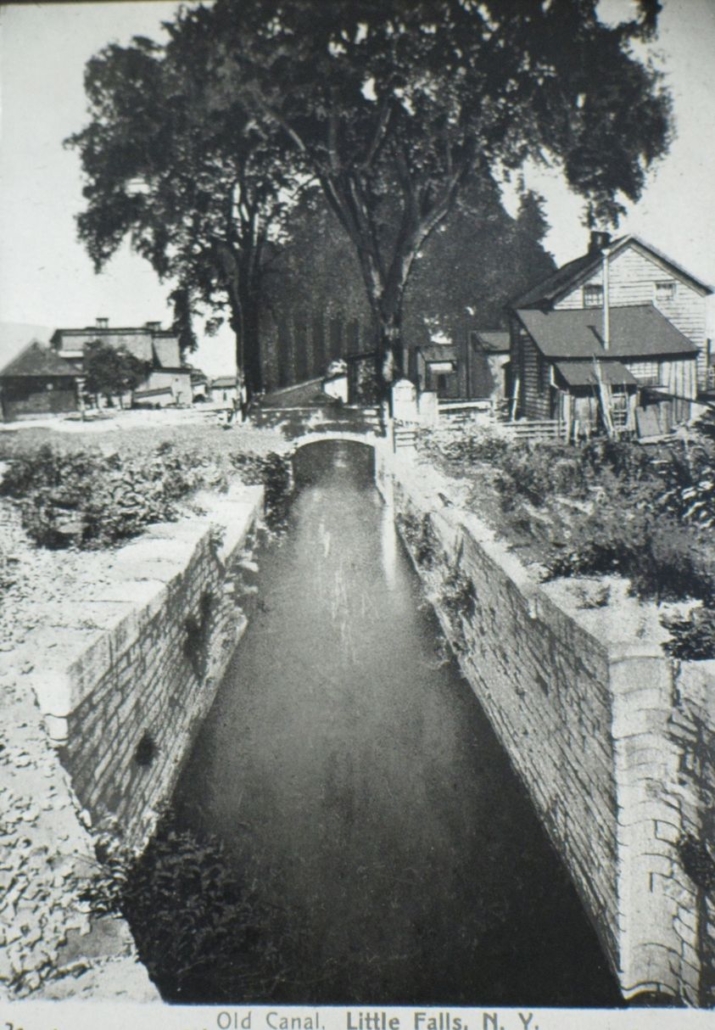
    This short canal was 4,752 feet in length, with 2,550 feet of it cut through solid rock. It had an aggregate fall of 44 feet 7 inches. The WILNC prism was cut 35 feet in surface width, tapering down to a bottom width of 26 feet and a depth of 3 feet. It included 5 wooden lifting locks that had been excavated from solid rock, with each having a lift of nearly 9 feet. Each lock chamber was 74 feet in length and had a width of 12 feet. A guard lock, a non-lifting lock, was built on the upper end of the canal to prevent the redundancy of water.

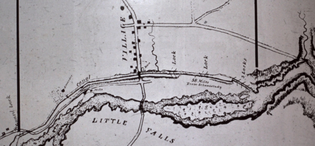
    The route of the WILNC at Little Falls, ran on the same path as the portage for the Little Carrying Place, on the north side of the Mohawk River. The canal: started at the guard lock, which is still present today on Riverside Industrial Parkway; it then continued down West Mill Street; a lifting lock was located at the intersection of Second and East Mill Street; another lifting lock was located at the old Cherry-Burrell’s plant; three lifting locks were located at the end of East Mill Street, in the raceway of the old Burrow’s Paper Mill which is known today as Twin Rivers; and it then exited into the Mohawk River.

    The short canal at Little Falls was completed on November 17, 1795, with a cost of $22,500. A short canal was built at Rome, NY, being 1.7 miles and was completed in October of 1797. It contained 2 wooden locks, a feeder canal and 2 dams made from bricks.

    Another short canal was built, with this one being at German Flatts, NY, which was 1.1 miles in length and was completed in 1798. It was built with a low dam, a guard lock and a 12 foot lift lock. They used Little Falls stone to build the locks here, with them being the oldest unmodified locks on the canal system. The rapids named “Wolf Rift” and “Orendorf’s Rift” were eliminated by the straightening of the canal.
    From 1802 through 1803, four locks were built at Wood Creek (is a 20 mile river that flows westward from Rome) which turned the low water areas in Wood Creek into a series of pools that could be easily traveled over by boat, eliminating the Oneida Carry, at the Great Carrying Place.

    The wooden locks along the canal were replaced with stone locks in 1803. The WILNC Canal was met with many repairs as it was being constructed and was completed in 1803 at a total cost of $367,743. John Porteous was the first collector of tolls for the WILNC at Little Falls, with a toll of $25 per ton to start with, eventually being reduced to $1. per ton.

    Once the canal was up and running, a much bigger boat replaced the Bateaux Boats, the Durham Boat, which could easily navigate the canal, which was propelled forward by sails, oars and poles. The Durham boat could carry up to 15 tons and was up to 60 feet in length, 20 feet in width and could cover up to 25 miles a day in water travel.

    The canal of the Western Inland Lock Navigation Company was not a profitable venture. In 1821, with the company just breaking even financially, they sold the canal to the State of New York. New York State gifted the WILNC to Little Falls in 1833, with it then being used as a feeder waterway to the Erie Canal. By 1840, the canal was used as a raceway for industries along Mill Street. In 1940, the old lock, which is located on Elizabeth Street, caved in and it was rebuilt using the original stone.

    From 1990 through 1993, lock remnants along the WILNC were excavated by the NY State Museum of Albany, which was led by Senior Scientist of Archeology, Phillip Lord, Jr. The 1795 Guard Lock at Little Falls was excavated in 1992, by the NY State Museum.

    *Digitizing of Historical Photo by Gail & Mike Potter, Article written by Darlene Smith
    1834 Western Inland Lock Navigation Blue Line Map

    Explore our history

    • The Privy and the Pear Tree: Unearthing Little Falls History in Your Own BackyardJuly 15, 2026 - 2:42 pm
    • Francis Skinner Municipal PoolFrancis Skinner Municipal Pool
      More than 150 Donors Help Reopen Francis Skinner Municipal PoolJuly 1, 2026 - 5:00 pm
    • COMMITTEE OF FIVE PRESENTING THE DECLARATION OF INDEPENDENCE TO CONGRESS IN 1776.
      THE DECLARATION OF INDEPENDENCE 1776 – 2026June 26, 2026 - 8:01 am
    • Little Falls Historical Society Membership PicnicJune 5, 2026 - 1:51 pm
    • Charles P Colby
      A Capacity For AchievementMay 7, 2026 - 7:35 am
    • Fort Herkimer Church
      Patriots Day Event Saturday, May 16, at the Fort Herkimer ChurchMay 5, 2026 - 8:55 am

    Explore the history of the Mohawk Valley

    Visit MohawkValleyMuseums.us

    Museum Exhibits

    • Little Falls and Women's Suffrage
      Little Falls and Women’s Suffragein: Current Exhibits
    • Rockton Exhibit | Little Falls Historical Society | Little Falls, NY
      Rockton Exhibitin: Current Exhibits
    • Camp Jolly Little Falls Historical Society Museum
      Camp Jolly Exhibitin: Current Exhibits
    • Prohibition Exhibit | Little Falls Historical Society | Little Falls, NY
      Prohibition Exhibitin: Current Exhibits
    • Athletics Wing | Little Falls Historical Society | Little Falls, NY
      Athletics Wing Collectionin: Current Exhibits, Ongoing Exhibits
    • 1940 train wreck | Little Falls Historical Society Museum
      1940 Gulf Curve Train Wreckin: Ongoing Exhibits, Past Exhibits
    • Native American Exhibit | Little Falls Historical Society Museum | Little Falls NY
      Native American Exhibitin: Ongoing Exhibits
    • Little Falls Diamonds Exhibit | Little Falls Historical Society Museum | Little Falls NY
      Little Falls Diamonds Collectionin: Ongoing Exhibits
    • World War II Exhibit | Little Falls Historical Society Museum | Little Falls NY
      World War II and Korean Conflict Exhibitin: Past Exhibits
    • Little Falls Cheese Market | Little Falls Historical Society Museum | Little Falls NY
      First U.S. Cheese Market Exhibitin: Ongoing Exhibits
    • Myjava, Slovakia Exhibitin: Ongoing Exhibits
    • Little Falls Waterwaysin: Past Exhibits

    Explore events happening in the Mohawk Valley

    See what's happening on MohawkValley.Today

    OLD BANK BUILDING MUSEUM HOURS

    By appointment only after October 4, 2025 until May 2026.
    SPECIAL DATES:
    OPEN SATURDAY, OCTOBER 11, 9-2
    OPEN FOR CHRISTMAS IN LITTLE FALLS ON SATURDAY, DECEMBER 13TH

    Explore the history of the Mohawk Valley

    Visit MohawkValleyMuseums.us
    © Copyright Little Falls Historical Society Museum in New York. All rights reserved. Design by MohawkValley.today
    • Link to Facebook
    • Link to Instagram
    • Link to Mail
    • Home
    • Exhibits
    • Historical Tours
    • Making History Today
    • News
    • Membership
    • About
    • Annual Report
    • Our Sponsors
    Link to: THE MAGNIFICENT MILE : PORTAGE TO PRESENT THE LITTLE CARRYING PLACE PART I Link to: THE MAGNIFICENT MILE : PORTAGE TO PRESENT THE LITTLE CARRYING PLACE PART I THE MAGNIFICENT MILE : PORTAGE TO PRESENT THE LITTLE CARRYING PLACE PART ICirca 1880’s Rufus Grider Pencil and Graphite Drawing: “Little Falls Rapids” Link to: THE MAGNIFICENT MILE: PORTAGE TO PRESENT GRAND ERIE CANAL: 1825 PART III Link to: THE MAGNIFICENT MILE: PORTAGE TO PRESENT GRAND ERIE CANAL: 1825 PART III The 4 short Red Arrows show the Locations of the 1825 Erie Canal Locks | E36 : Lock 36, known as the Mile Lock, which had a mule shed, where mules could be rented; E37 : Lock 37, which was known as the Van Allen’s Lock, which was a mechanics drydock that was used for boat repairs; E38 : Lock 38, which was known as Perry’s Lock: and E39 : Lock 39, which was known as Leigh’s Lock. | The route of the 1825 Erie Canal is shown on the map with a dotted line on the south side of the Loomis, Seeley and Moss Island | Also marked on the map is a longer Red Arrow marking the location of the 1822 Aqueduct | Circled in Red is the 1795 Guard Lock of the Western Inland Lock Navigation Canal, with the canal path shown on the map with Black Dots, that also includes the 5 lift locks, shown with the symbol ofTHE MAGNIFICENT MILE: PORTAGE TO PRESENT GRAND ERIE CANAL: 1825 PART III
    Scroll to top Scroll to top Scroll to top