THE MAGNIFICENT MILE: PORTAGE TO PRESENT GRAND ERIE CANAL: 1825 PART III
THE PROPOSAL
The Western Inland Lock Navigation Canal (WILNC) was the catalyst for growth in the Mohawk Valley and of the western frontier in the late 1790s. This growth made it necessary for improvements to be made in water transportation. In 1803, a proposal was made by then New York Governor Morris to Simeon DeWitt to create a continuous waterway route through the wilderness of upper New York State, connecting the Atlantic Ocean to the Great Lakes through a natural break in the Appalachian Mountains. From 1808 to 1811 many surveys of different feasible routes were carried out.
New York State had been pursuing this canal venture for years, when President Thomas Jefferson stated the building of this canal was a hundred years too soon and also quipped “…it’s a little short of madness…”. President James Monroe denied a request that was submitted by New York State for financial funding, with the Erie Canal eventually being state funded through the use of stocks and loans from private investors.
The canal project was delayed for three years because of the War of 1812, during which time 300 military boats passed through Little Falls in one day on the WILNC, emphasizing the need for a canal.
In 1816 DeWitt Clinton, known as the “Father of the Erie”, while campaigning for Governor, wrote a document called the “New York Memorial” that was sent to the Legislature, stating that a canal would bring growth and prosperity to New York, which the proposal was accepted on April 15, 1817.
DEVELOPING THE ROUTE
The chosen navigable 363 mile canal route was from Albany, on the Hudson River to Buffalo, on Lake Erie. This route, being the first American artificial continuous inland waterway, was recommended by a Syracuse, New York salt miner, Judge James Geddes, who had surveyed various canal routes with Judge Joshua Forman’s 1808 Canal Bill.
This waterway, the Erie Canal, would allow communication into western New York, with trade, travel and the growth of settlements to follow, fulfilling George Washington’s words during his 1783 Mohawk Valley visit at Little Falls.
OPPOSING CLINTON’S DITCH
On July 4, 1817, canal work began on the “Middle Division” at Rome, New York. The canal had been referred to as “Clinton’s Ditch” by its opponents and was pushed into existence by New York Governor DeWitt Clinton and Jessie Hawley, a flour merchant from Geneva, New York. Hawley spent years, unsuccessfully, trying to get his flour to the east coast. By doing so, he accumulated unpayable debts and he was sent to debtors’ prison. While in prison, Hawley published fourteen essays on “the whys and hows of favoring a canal being built”, with these essays gaining the attention of Governor Clinton. His opponents felt the building of the canal would only benefit upstate New York, for in the end, its existence made New York City the largest, and most important port on the East Coast.
ENGINEERING OF THE CANAL
At this time, there were no American educated engineers, so lawyers, surveyors and schoolteachers used “Yankee ingenuity”, becoming self taught, to take on the task of building the Erie Canal.
The canal at Little Falls was in the “Eastern Division” under the supervision of engineer Charles C. Broadhead. Contracts were given out for each three mile stretch within this section, stimulating the local economy with the steady work. An estimated 3,000 workers, with a large percentage being Irish and the rest being of local men, along with 700 horses, hand dug this section of the channel with pickaxes and shovels.
The Irish suffered many abuses because of their religion and themselves being foreigners. The first Catholic church, St. Mary’s of the Assumption, was built in Little Falls in 1847 to accommodate the beliefs of the large Irish population that had settled in Little Falls.
The canal prism had a depth of 4 feet, a surface width of 40 feet and a bottom width of 28 feet. Machinery was made as needed, such as a stump puller that could remove 40 stumps a day, a one-man tree feller by using an endless screw, and an improved wheelbarrow to move dirt. The laborers were faced with disease and injuries, with a pay of 50 ¢ to a dollar a day.
The walls of the canal were built of stone set in clay, with the bottom being lined in clay, making the channel water tight. The earth that was removed from the canal was usually laid on its north side to form a towpath. The towpath was 10 feet wide and was used by the driver of the horses and mules that pulled the canal boats that had a draft of 3.5 feet or less. A mule driver, also known a “Hoggee”, which is the Scottish term for a person who drives animals on the canal, were usually children. The animals were given the commands “ho” to stop and “gee” to go.
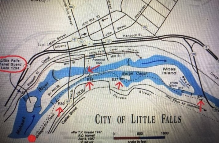
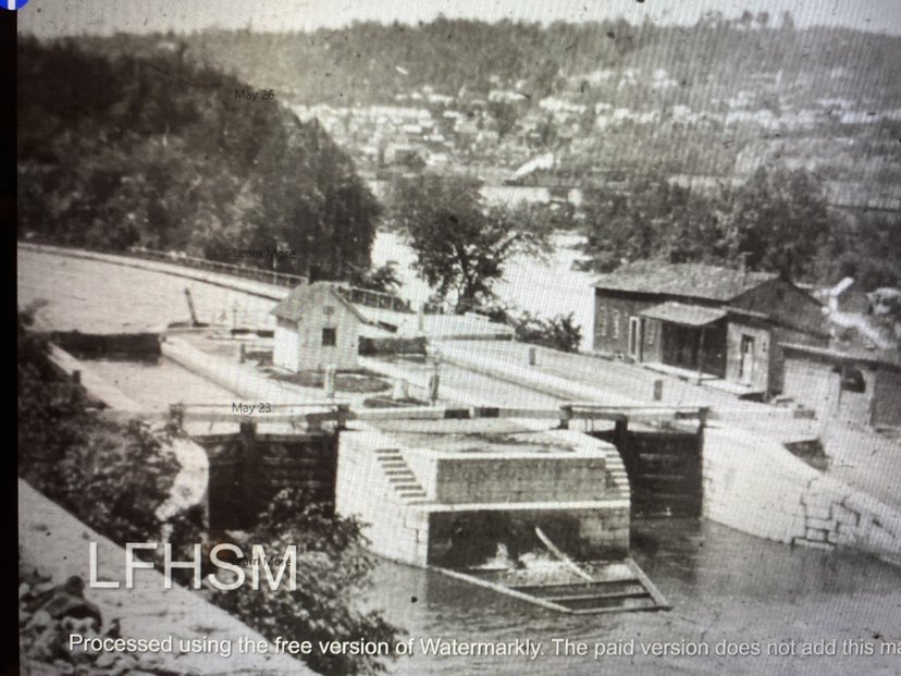
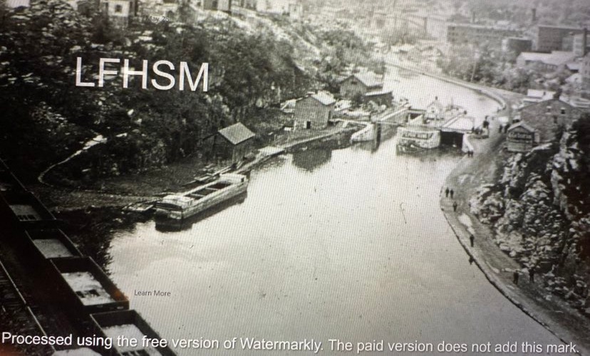
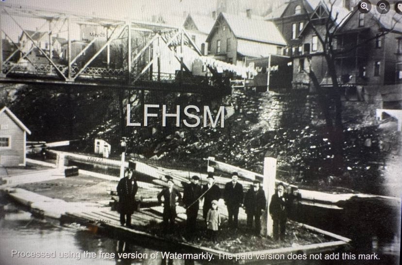
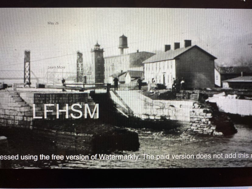
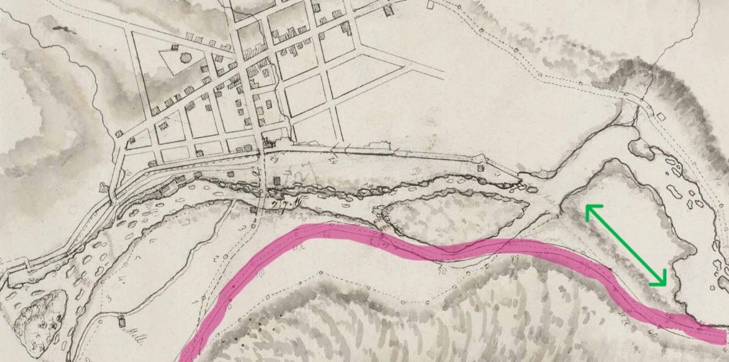
For the water to remain level between the locks for 363 miles, it took the use of 83 stone locks that were built along the canal. They accommodated the lift of 565 feet in elevation from the Hudson River to Lake Erie. Little Falls is 410 feet above sea level. The locks were 90 feet long by 15 feet wide, with wooden lock gates that were designed to be operated by one person. The locks were made of local stone and natural hydraulic cement . The hydraulic cement was made from limestone quarried at Chittenango, New York by Canvass White, an engineer who was trained in England. The canal at Little Falls had four of these locks, being Locks #36, #37, #38 and #39. Remnants of three of the old locks can be seen along the canal today, with their locations shown on the map of the first included photo.
The canal ran through lands belonging to the Iroquois Confederacy, causing many Native American Indians to be relocated to far away reservations, with Native American Indian removal policies taking shape in America during this time.
A BRIDGE FOR BOATS | THE AQUEDUCT
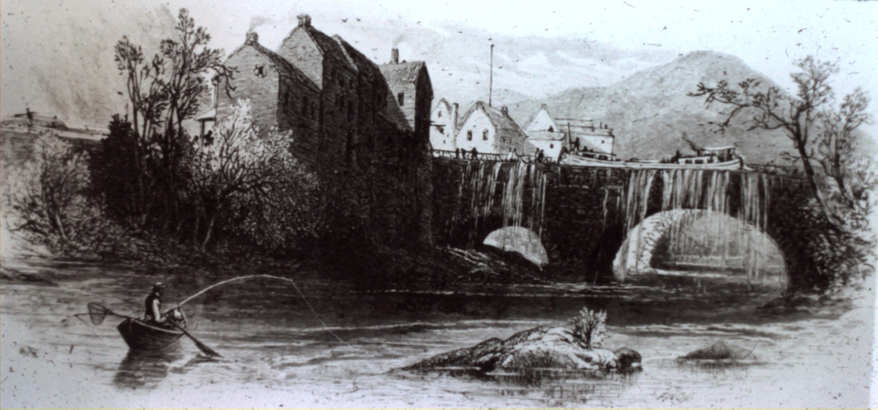
The Erie Canal was designed to avoid natural bodies of water, with eighteen aqueducts being built over rivers to reach canal villages for trade and transportation. The proposed route of the Erie Canal would be south of the Mohawk River at Little Falls, and therefore would bypass the city completely. This ensued the merchants to lobby for a water connection to their businesses, which resulted in the construction of an aqueduct in 1822.
The aqueduct spanned the Mohawk River, allowing boat traffic on the Erie Canal to enter the Little Falls harbor basin and also allowed them a connection with the 1795 Western Inland Lock Navigation Canal. The aqueduct’s tow path was made out of wood.
This amazing structure was built of hand cut limestone. A stone mason from Utica, Ara Broadwell, built this structure in 8 weeks. He also built canal locks, culverts, and other aqueducts along the Erie Canal. He received a payment of $45,532.50 from the State of New York in 1822, for the building of the Little Falls Aqueduct and seven locks above the falls.
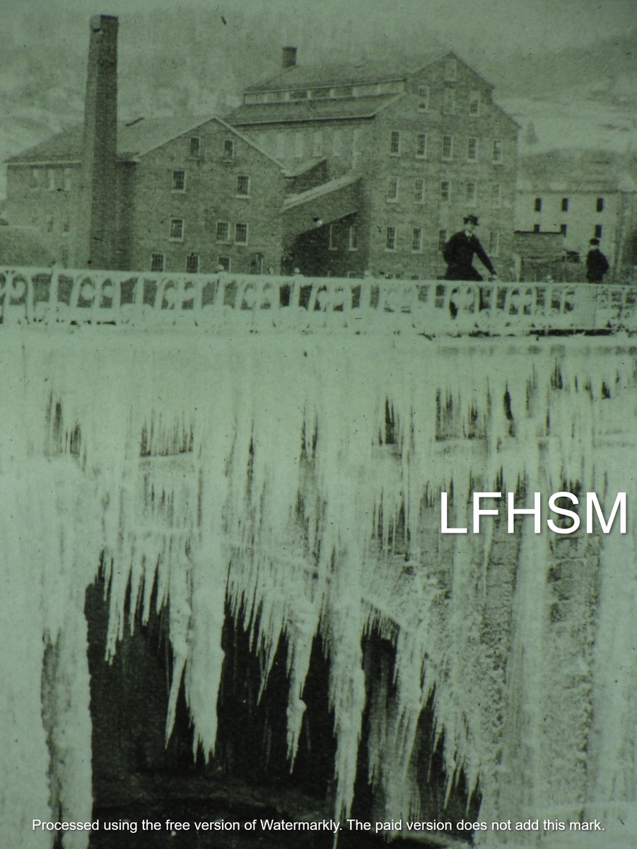
The Little Falls Aqueduct consisted of three arches. The middle arch spanned 70 feet across the Mohawk River, with the two side arches each spanning 50 feet. The arches supported two 4.5 feet high side walls, with the waterway being 16 feet wide and 214 feet in length.
It had a marble slab plaque attached on the middle arch, that was inscribed by Erastus Cross in 1822, that read as follows:
Erected in 1822 : Commenced Aug.23 – Completed Oct.15
Canal Commissioners:
DE WITT CLINTON, President.
STEPHEN VAN RENSSELAER,
SAMUEL YOUNG, HENRY SEYMOR,
MYRON HOLLEY, WILLIAM C. BOUCK
HENRY SEYMOUR, Acting Commissioner,
BENJAMIN WRIGHT, Chief Engineer.
CANVASS WHITE, Assistant,
ARA ROADWELL, Builder.
It remained in service until June of 1881, when one side burst open and was drained and abandoned. By December of 1881, the Canal Commission had abandoned the aqueduct and feeder and offered them up for sale. The aqueduct’s north arch was demolished in 1891 for factory expansion and the south arch fell in 1928. Flood waters in 1993 took down the central arches. A few stones remain at the base on the southern side of the aqueduct that can be seen from the Ann St Bridge to Benton’s Landing.
The boat basin, known as Little Falls Harbor, was built into the WILNC. To the west of the harbor, the WILNC was used first as a canal feeder and in 1836 the feeder was converted into a raceway for industries by Arphaxed Loomis, who also had built a stone dam on the river to harness the Mohawk River for water power. The village received a 1882 deed to the basin from Arpahxed Loomis, the first judge of Herkimer County. Land divisions had set the eastern boundaries for Herkimer County in 1791. Up until this point in time, the south side of the village was in Montgomery County. The Little Falls Harbor first became Clinton Park and years later it became a municipal parking lot. The lot eventually became known as the Showcase Antiques of CNY of today.
ERIE CANAL AT LITTLE FALLS
In the autumn of 1821, the early Erie Canal flowed east from Utica into Little Falls following close to what is now the “Erie Canal Bike Trail”, crossing over State Route 167 to the Erie Canal Road. From there the Erie Canal, harnessed by gravity, traveled through what is now the median between State Route 167 and Flint Avenue. The Erie Canal was on the south side of the Mohawk River and flowed parallel to the river. The canal continued to flow gradually north to where the Guard Gates # 4 are located. It then descended east for a mile through the use of the 4 locks, which provided over a 40.5 foot drop in elevation.
DID YOU KNOW… The channel for the Erie Canal cut through land mass on the south side of the village creating an artificial island, Moss Island.
The Erie Canal then joined the Mohawk River near the current Lock 17.
OPENING OF THE ERIE CANAL
In 1825, Marquis La Fayette was the first notable to stop at Little Falls. A signal gun being fired announced his arrival a little after midnight, on June the 11th. Lafayette was welcomed with a bonfire on the aqueduct, where a large crowd had gathered throughout the day awaiting for his arrival. He had stalled his travels on the Erie Canal at the toll collectors office, long enough to shake the hands of the committee that appointed the salutations from the village, with his departure an hour later.
New York Governor Clinton left Buffalo on the 26th of October, officially opening the Erie Canal with a ten day celebration tour to Albany, his boat being the first boat to be pulled the entire length of the canal that had taken eight years to complete. Clinton rode upon the boat “Seneca Chief”, being the leader of a flotilla boat parade. All the villages along the canal participated, with the Seneca Chief stopping at Little Falls at 10 a.m. the morning of the 31st. He was welcomed by Honorable Augustus Beardslee, along with band music being played along the aqueduct, led by band leader Elijah Case,Jr., leader of the newly formed Little Falls Military Band. The parade continued to Mckinster’s Tavern on Main St., which is where M&T Bank is located today. A large feast was held in Clinton’s honor. Governor Clinton continued his trip to the New York Harbor where he poured a keg of water from Lake Erie into waters of the Atlantic Ocean. On his return trip to Buffalo, he brought with him a keg of water from the Atlantic Ocean which was poured into Lake Erie by Judge Samuel Wilkeson, completing “The Wedding Of The Waters.”
COST OF CLINTON’S FOLLY
On July 21, 1820, tolls began to be collected for the use of the canal by the navigators. The staggering amount of $7,143,789. to build the canal was paid off in ten years by the use of toll collections, with John Porteous being the first collector of tolls at Little Falls. Navigators on the canal had to stop at one of the five weigh-lock buildings located on the canal to have their boats weighed by a massive scale system, which determined the toll charge for the use of the canal. The collection of tolls stopped in 1883.
Little Falls was considered for a New York State Canal Museum in 1958, to be built on Moss Island in the old “Adirondack Woolen Mill.” The remnants of the Adirondack Woolen Mill can be seen today on Seeley Street, which was the starting point for Herkimer’s mile long portage route on the north side of the Mohawk River. Little Falls was passed over in 1962 for the canal museum being built in the weigh lock building at Syracuse, N.Y.
CANAL BOATS
Soon after the completion of the canal, new boat styles began to appear. There was the Packet Boat, being up to 90 feet long by 14 feet wide, that could travel up to five miles per hour. They were like a floating hotel that held up to 100 people during the day and up to 40 for the night. The captain often carried his whole family on board for the season. The packets had the right-of-way upon traveling and they changed the mules every 15 miles, with some boats having a stable on board to carry their own mules.
There were also Line Boats that were used for passengers and freight. They also had Freight Boats that were allowed to carry freight up to 30 tons, with a cost of $10 per ton per mile, at a traveling rate of 4 miles per hour, going from Albany to Buffalo in nine days. Previously, land travel took 15 days to go from Albany to Buffalo, at a cost of $100 per ton per mile.
CANAL LIFE
The canal had a lively atmosphere, with floating stores, libraries, hotels, circuses, museums, and showboats. They also had floating churches to combat the use of alcohol and gambling. Two canal side recreational parks near Little Falls were Camp Jolly and Taylor Driving Park, with the canal providing steamboat transportation to these canal side destinations. The first steam boat came through Little Falls during May of 1839. Pleasure boating came to a halt after the explosion of the “Titus Sheard” steamboat on June 18,1896. A small group of people on board were heading to the Taylor Driving Park, when the boiler exploded killing 12 people.
Disease was also “transported” on the canal. Asiatic Cholera had traveled from Europe and proliferated in America, with a case being reported in Little Falls in 1832. An ordinance had been passed for the protection of the villagers. It stated “no boatmen or person shall land or set ashore from the Erie Canal and no inhabitant shall let a sick person in the house or inn without a certificate from the village president and physician stating the person is not afflicted with cholera”.
CANAL ALTERATIONS
To keep pace with the increase of the boat traffic after its completion, plans were made to increase the capacity of the canal. From 1836 through 1862, the Erie Canal received a series of construction alterations, with a cost of $32,000,000.
Aqueducts were rebuilt, with Little Falls being the only unaltered one, whose remains can be seen off to the left side of Ann St. Bridge. In 1841, during the reconstruction at Little Falls, the canal was dug to a depth of 7 feet and was widened to 70 feet at the surface, and the bottom to 55.5 feet in width.
DID YOU ALSO KNOW… The removed earth was used to make dykes on each end of Seeley Island, resulting in Loomis, Seeley and Moss Island to be one large artificial island mass that contains 30 acres.
The canal was reduced in length to 350 miles and the size of the locks were increased to 110 feet in length and to 18 feet in width. The locks at Little Falls were not lengthened but were each made into a double lock in 1884, allowing boats to travel through in either direction at the same time.
LITTLE FALLS, A CHEESE CAPITAL
The reconstructed Erie accommodated larger freight boats that could now haul up to 250 tons of goods at cheaper rates. As the canal increased in size, so did the size of its boats. The canal allowed products to easily reach far away customers with low shipping costs and short travel times, which combined, promoted commerce between the canal towns and far away cities and countries. With this, Little Falls had become known as the “Cheese Capital of the World” and had the first Dairy Board of Trade established in America in 1871. The Burrell family, builders of Burrell’s Mansion that stands at 55 Douglas St., were the first to ship American cheese to England. Rennet, an important ingredient used as a stabilizer in the making of cheese, was manufactured at Chr. Hanson’s Laboratory on an Island in the Mohawk River, Hansen Island.
THE BEGINNINGS OF A CANALSIDE VILLAGE
In 1811, the canal was a major entryway into the newly incorporated Village of Little Falls. It influenced many new businesses to quickly appear upon the Loomis, Seeley and Moss Island land mass to cater to the needs of the boaters. The island held mills, grocery markets, dry goods stores, tenant housing, private homes, hotels, saloons and liveries. Many of these businesses were open for many hours each day, for the canal operated 24 hours a day, every day of the 9 month boating season. During the winter, the water level was low and usually frozen, which provided recreation in the form of ice skating.
Benton’s Landing, a transient docking area located at the end of historic Canal Place on the Erie Canal, is the name sake of a War of 1812 veteran- Judge Nathaniel Benton, whose historic home can be seen at 534 Garden Street . Benton’s house was gifted to the City of Little Falls by the D.H. Burrell family in 1920, as a meeting place for non-profit organizations, and was also used as a boarding home for women in need, which is still being used in that capacity today. The elementary school at Little Falls was named in Benton’s honor, Benton Hall Academy.
The canal was making the people of Little Falls prosperous, but the village itself could not expand. In 1827 Little Falls acquired a 3rd charter drafted by the newly elected first Village President, Nathaniel Benton, at the Old Stone School House, which can be seen at 15 Church Street. The charter stated for the Ellice Estate to build new streets at their expense for the expansion of the village. Up to this time Little Falls had just two streets, Ann and Catherine Streets, being the old Mohawk Turnpike Road, which was a former Indian and wagon trail.
Edward Ellice, son of Alexander Ellice, whose English family made their wealth in the fur trade and were leading members of the Hudson Bay Company owned 1200 acres of land at Little Falls that covered almost the whole village on the north side of the Mohawk River. He refused to sell the land lots, for he was receiving high rents for their use. By 1831 Legislature had passed a bill, championed by Judge Arphaxed Loomis stating that no alien could own land in New York State. Judge Loomis’s 1832 historic home can be seen at 676 East Main Street. With the Ellice Estate owning large tracts of land in other parts of N.Y., he had been coerced into selling off his landholdings at Little Falls for the sum of $50,000. The bill was canceled as soon as the transaction for the sale was completed, with the Ellice Estate being allowed to maintain ownership of their other New York State properties. The Little Falls landholdings were divided up into water lots and sold. Over the course of a few years these lots became the property of President James Monroe’s nephew, James Monroe and Richard Ray Ward, separately. They in turn sold the lots out to individual industrialists. Monroe’s historic 1867 home can be seen at 540 East Monroe Street and the Richard Ray Ward Mansion is located at 721 East Main Street. The growth of the population had quadrupled by 1830, with 2,539 people living within the village.
A TRUE CANALSIDE VILLAGE
The increase in commerce because of the Erie Canal, led the citizens’ of Little Falls to need a banking institution. Up to this point, cash money was rarely seen, with the use of bartering being the main purchasing system for needed goods. In 1833, the first bank in Herkimer County was built in Little Falls, the Herkimer County Bank, which now houses the Little Falls Historical Society Museum at 319 South Ann Street. The stone mason for the bank, Robert Stewart, also worked on the aqueduct of 1822.
By the 1860s, the population had grown to 5,000, with the Industrial Revolution taking hold in Little Falls, making it a textile mill center of the Mohawk Valley. New industries were appearing along the waterways, with their owners building new homes in the village center, making Little Falls a true canalside village.
*Digitizing of Historical Photos by Gail & Mike Potter, FROM THE COONEY ARCHIVES: THIS DAY IN HISTORY by Louis Baum, JR, Article written by Darlene Smith

